Blue carbon project with Community of Arran Seabed Trust
Published: 22 August 2023
Conducting field surveys, ground truthing exercises and primary data collection regarding blue carbon habitats and their carbon storage potential on the Isle of Arran.
Project overview
Marine environments are known to store and sequester vast amounts of carbon known as “blue carbon”, but determining exactly how much is very challenging.
In assessing, monitoring and gaining a greater insight into these habitats, we can begin to understand their value as a natural climate change mitigation measure, and further underpin their value as long-term stores of CO2 which require protection from external threats.
Our solution
Sampling and surveying different marine habitats helps us to build a picture of their health and effectiveness at storing CO2.
We conduct field surveys in order to know exactly how efficient these carbon stores are, and monitor these environments long term to understand if they face any external pressures which can be managed
What we did
The Whiting Bay seagrass bed on the eastern shores of Arran is believed to be the largest seagrass bed in the Clyde. Seagrass is a highly productive habitat, capable of capturing and storing large amounts of carbon within the plant material and underlying sediments.
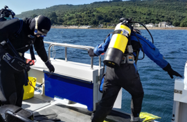
Initially we completed dive surveys along a 50m transect in a southern section of the bed which hadn’t been surveyed before. We placed quadrats along the transect and assessed the density, shoot length, epiphyte coverage and underlying substrate of these beds.
We conducted drop-down video (DDV) surveys around the north and eastern coasts of Arran. DDV is a great inexpensive way to collect footage from a large underwater area, and involves lowering a camera to just above the seabed in order to record footage of a survey area (it really can be as simple as a GoPro on a pole). We deployed 12 DDVs in total, each lasting 5 minutes, and tracked our movements via GPS so we could map the survey areas using GIS software. We watched this footage back and recorded data on all of the habitats observed.
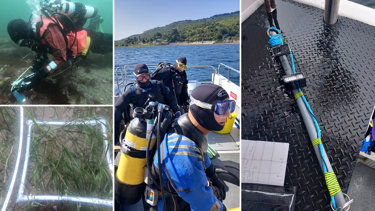
We surveyed in and around Brodick Bay, Holy Isle and Lamlash Bay, as well as taking the first known recordings in Lochranza.We also conducted snorkel surveys in Drumadoon where we discovered a new section of seagrass within the South Arran MPA. To our knowledge this area has not been assessed before, so finding this seagrass was a real bonus. The seagrass here is quite patchy, so we snorkelled across sections of the bed, recording waypoints on a GPS unit whenever we were above a patch. These way points will be mapped in GIS, providing an indication of the extent of the bed.
We also surveyed a large bed of kelp near the shoreline using a GPS in tracker mode. From a carbon perspective, kelp is viewed as a carbon donor rather than a sink, as its primary means of developing carbon stocks is through donation to other ecosystems which feed on and accumulate within the detritus (waste material).
We finished taking core samples from the seagrass beds in Whiting Bay. These samples will be sent for carbon analysis, which will tell us how much carbon is being stored in the underlying sediments. Seagrass carbon uptake can differ by geographic location, so taking these samples enables us to estimate a more accurate carbon value of seagrass within the South Arran MPA.
Outcome and results
Understanding the carbon storage of marine environments can help to inform marine policy and spatial planning, to ensure no damage occurs to the habitats.
Preserving and enhancing these habitats will encourage sustainable use of marine spaces, protect vulnerable species, and help on the road to Net-Zero.
Why Adler and Allan?
We have experience conducting desktop assessments of blue carbon habitats, as well as demonstratable skills in field survey techniques.
We have worked alongside the Scottish government to produce habitat suitability models in GIS for the entire network of Scottish islands, outlining potential areas for targeted surveys.
Additionally, we have undertaken a range of survey techniques including drop-down video recordings, snorkel and dive surveys, core sampling and carbon analysis.
We can provide an end-to-end approach to assessing blue carbon stocks and habitat potential for carbon storage in areas around the U.K, and are engaging with industry leaders surrounding best practises, most relevant research, and methodologies.
More from our Knowledge Hub
 News
NewsAdler & Allan announces new investment from Private Equity at Goldman Sachs Alternatives
 Insights
Demystifying the new biodiversity net gain legislation
 Case study
Blue carbon habitat suitability assessments in Scotland as part of Carbon Neutral Islands project
 Insights
Changes to ESOS reporting system and compliance notification deadline extended to 6 August 2024
Keep your business compliant and protect the environment while reducing the risk of operational downtime
Find out how Adler and Allan reduce your risk and support you on your journey to Net-Zero through the management and maintenance of assets.
Contact our experts