Blue carbon habitat suitability assessments in Scotland as part of Carbon Neutral Islands project
Published: 17 April 2024
The problem
The Carbon Neutral Islands (CNI) project is a Scottish government programme aimed at supporting six identified islands to become carbon neutral by 2040. One island has been selected per local authority: Great Cumbrae (North Ayrshire), Islay (Argyll & Bute), Raasay (Highlands), Barra & Vatersay (Outer Hebrides / Comhairle Nan Eilean Siar), Hoy & Walls (Orkney) and Yell (Shetland).
The definition of ‘carbon neutral’ in the context of this project means an island where the greenhouse gas (GHG) emissions from activities are in balance with carbon sinks such as woodland, peatland and ‘blue carbon’ habitats.
The Scottish Blue Carbon Forum (SBCF) defines “blue carbon” as: “The carbon captured and stored in marine and coastal ecosystems that accumulates over long timescales through natural processes. In Scotland, blue carbon habitats include saltmarshes, seagrasses, kelp beds, biogenic reefs and geological sedimentary stores, such as seafloor and sea loch sediments.”
As only a small proportion of the seabed has been surveyed for such species, Adler and Allan were commissioned to conduct research into where these blue carbon habitats may be.
Within the scope of this project, biogenic reefs were taken to include: maerl beds, brittlestar beds, flame shell beds, horse mussel beds, bryozoan thickets, serpulid aggregations, cold-water coral reefs, native oyster beds and blue mussel beds.

The solution
We defined ‘blue carbon boundaries’ around each of the islands and then gathered all available evidence to highlight where relevant habitats are known to be, or are likely to be, or where conditions are potentially suitable for habitat creation/restoration.
The findings of the study were used to develop a ‘ground-truthing’ strategy with several different survey techniques used to collect site specific data related to habitat extent, density, coverage, and the health of these blue carbon habitats.
This gathering of evidence would enable the production of more accurate and verified blue carbon habitat extent maps. These maps, together with evidence gathered on the carbon storage and sequestration values associated with different blue carbon habitats and oceanic sediment, can be used to better understand how much carbon is stored (in carbon sinks) and how much carbon is sequestered (the amount captured per year) by the marine environment surrounding each island.
Understanding the carbon storage of marine environments can help to inform marine policy and spatial planning, to prevent damage to these valuable habitats. Preserving and enhancing these habitats will encourage the sustainable use of marine spaces, protect vulnerable species, and help islands on the road to Net-Zero.
To define the blue carbon boundaries around each island, Adler and Allan established a 3-mile buffer around the coastline of each island (in line with the water framework) or determined the halfway point between two land masses – whichever was less.
We then conducted a detailed examination of available literature (both on a national and international scale) to collate the information available regarding relevant blue carbon ecosystems. This included the distribution and requirements of key species and habitats required for this study, as well as carbon density values and carbon sequestration rates.
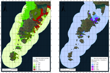
Large gaps were identified in the available data which verified spatial extents of blue carbon habitats around the Scottish islands, with the exception of saltmarsh and seafloor sediment which had been extensively mapped. We therefore used what was available – presence point data - to model the probability of occurrence for habitats including seagrass, kelp, maerl, bryozoan thicket, serpulid reef, horse mussels, flame shells and brittlestar. Each species prefers different environmental conditions and can only thrive if the conditions are suitable. We assessed a suite of environmental variables (e.g. light, substrate, temperature, wave exposure, current, and dissolved oxygen concentrations) to provide an estimated probability of presence for each species and highlight areas where there is potential for the species to be introduced in the future.
The predictive model highlighted areas where there is a >90% likelihood that the conditions are suitable for each species. Following this, ground-truthing surveys were designed and targeted in the >90% areas to determine firstly; if the species was indeed present and, if so; in what condition. If the species was not present, other tests were carried out to determine if there were specific factors impacting the ability for that species to thrive – e.g. water quality, pollutants, pH, sediment types, microclimate etc.
Together with the carbon density and sequestration values, these habitat suitability maps make it possible to gain an understanding of the storage and sequestration potential of blue carbon habitats around each island.
Project outcomes
Following successful completion of the project and a positive reaction from island communities, we were subsequently commissioned to conduct the same exercise for all 93 inhabited Scottish islands.
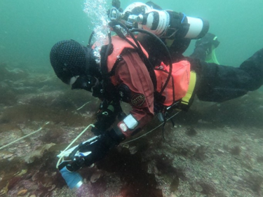
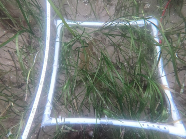
As a follow up to this project, we conducted a pilot study to verify blue carbon habitats. A five-day field study was carried out, including a range of survey and sampling techniques for mapping and analysing marine habitats. Techniques included:
- Snorkel surveys to map kelp beds.
- Dive surveys using transects, quadrats and underwater videography to map and assess the condition of maerl and seagrass beds.
- Drop-down video surveys to investigate areas of interest highlighted by the predictive models.
- Sediment core sampling of seagrass beds to investigate the percentage of inorganic and organic carbon within the sediment.
This exercise provided valuable data to inform a growing dataset around UK blue carbon – and its potential role in a Net-Zero future.


The results
We can provide an end-to-end approach to assessing blue carbon habitat suitability and quantifying carbon storage and sequestration in accordance with the most relevant and up-to-date research and methodologies.
We have experience in conducting desktop assessments and literature reviews of blue carbon habitats, as well as demonstratable skills in field survey techniques, sampling and carbon analysis.
We are able to use GIS and maximum entropy modelling techniques to predict species and habitat distributions in both terrestrial and marine environments with limited available spatial data.
And finally, we can help you design, implement and validate your habitat restoration project in terrestrial, aquatic and marine environments.
More from our Knowledge Hub
 Case study
Setting the ‘gold standard’ in PFAS response and remediation after major transformer fire at national infrastructure substation
 Case study
Managing PFAS contamination following deluge testing at a national infrastructure substation
 White paper
PFAS and UK Industrial Sites: Why Delay Is the Most Expensive Strategy
 Insights
PFAS in your supply chain: The liability you didn't know you had
Environmental compliance today, creating a sustainable tomorrow
Helping you reduce risk to the environment and your operation by managing assets compliantly while achieving commercial, ESG, and net-zero goals.
Contact our experts