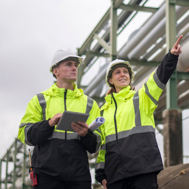
Geoenvironmental consultancy
Ready to discuss your project?
Please leave your details and a member of our team will reach out to discuss your requirements in more detail and arrange next steps.
We help anyone looking to develop their land, as well as their construction partners, to reduce delays and unknown risks and remove barriers.
We do this by combining technical expertise and a commercially focused approach to find solutions so that you can focus on delivering an effective and high-quality development.
Our knowledge and understanding of the planning and building control requirements, the underpinning LCRM process, as well as significant experience of managing the environmental requirements of land development projects ensures we meet and even exceed the National Planning Policy Framework definition of a competent person.
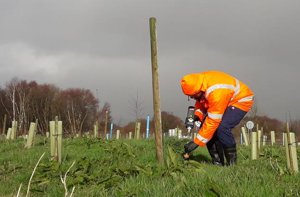
Our expertise in geoenvironmental considerations combined with our qualified ecologists ensure these risks associated with your development are effectively identified and expertly managed to meet your planning requirements.
Features and outputs
- Full end-to-end geoenvironmental assessment capability in-house.
- Capability to provide civil engineering and waste management capability.
- Experts in environmental management for construction projects.
- Qualified ecologists in-house to provide ecological surveys to cover full environmental assessments required prior to development.
Added value
Trusted partner
Know-how
Agility
Land contamination risk management (LCRM) process
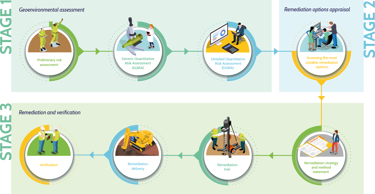
Stage 1 - Geoenvironmental Assessment
Phase 1 - Preliminary risk assessment
Desk study
As part of the desk study, we review maps, street names, the surrounding area, OS maps (historic and current), geology maps, client reports, development proposals and surveys. These may be publicly available, via a request for data, or purchased from third party providers. This study allows us to identify potential contamination and land stability issues arising from the expected ground conditions, site history, or if there has been any previous pollution incidents, and what the sites environmental sensitivity.
Site inspection
In the site inspection we are assessing what currently exists on site that might cause contamination and known impacts we can see, such as any visible contamination/distressed vegetation, any subsidence, and assessing what is nearby that could be affected such as streams, rivers, houses, and drainage routes.
The aim is to see if further assessment is needed (in many cases it is not) or to help us to design the next phase of work. By knowing what the ground like we can understand what type of drilling is required, potential sources of contamination, or geotechnical issues, and what type of contaminants there are likely to be. We can then design our investigation to drill holes in right place to test for the right things.
Phase 2 - Generic Quantitative Risk Assessment (GQRA)
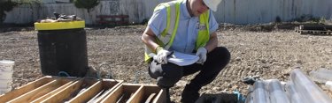
Soil and water sampling
If we suspect soil contamination, we drill holes, dig trial pits, undertake groundwater, and ground gas monitoring, and take soil and water (groundwater and/or surface water) samples to quantify what is there.
Soil and water samples are analysed at an accredited laboratory to confirm the level of contamination. Samples are split down to various compounds and results are compared to tier 1 screening values (published guideline values that define parameters for specific compounds). If no compounds exceed tier 1 screening values, then there is no risk. If any compounds do exceed tier 1 screening values, then there might be a risk and further assessment is required.
At this stage we also consider ground gas (methane, carbon dioxide, etc) risks.
Geotechnical assessment
At this stage we also obtain geotechnical data to assess ground stability and strength to help design suitable foundations and other structures for new development. These assessments ensure the buildings, structures and surfaces are designed in a way to ensure they’re stable and avoid settlement issues, subsidence, collapse, etc. We also look at coal mining risks, radon, and ground gas such as methane and C02.
Finally, we consider waste by taking samples of the soil and classifying whether the material is inert, non-hazardous, or hazardous in order identify an appropriate disposal route. We use this information to budget for and inform earthwork strategies on site and this is a requirement of landfill or reclamation facilities prior to accepting materials.
Waste Classification
Excess soil, often in considerable amounts, is produced during land redevelopment sourced from activities such as general earthworks/levelling, foundation excavations, etc. Particularly on brownfield development sites, these soils and materials can be one of the biggest potential sources of uncertainty, cost, and programme risk. However, excess soils are not simply ‘waste’, they are resources which could generate value for your project.
With wide experience managing soil and materials on a range of projects, from 1 m3 to 1,000,000 m3 and more, we are well placed to advise and identify solutions to make the waste management issues straightforward and predictable so that clients can deliver sustainable projects which optimise the value of the available resources.
Our services include:
- Initial waste classification and soil re-use options advice at feasibility stage.
- Site Investigation and earthworks sampling to classify wastes.
- Identifying and managing appropriate disposal options.
- Supervising bulk earthworks to segregate different materials into different waste streams.
- Advice and support on relevant environmental permitting issues.
Flood Risk Assessment
This assessment considers likely flood levels, previous incidents, how resilient a building is to flooding, and what mitigation could be put in place to minimise risk.
Further detailed assessment
If you are developing a site you need a preliminary flood assessment to work out the flood level (metres above ordnance datum) to allow you to build above potential the flood level. We can also work out what you need to do to reduce surface water run off rates to maintain the same levels as it were to remain in its current state. Options could include attenuation tanks or ponds to slow the flow.
Phase 3 - Detailed Quantitative Risk Assessment (DQRA)
Using site specific data obtained from previous investigation, and often supplemented by additional data designed to delineate areas of contamination, our experts populate appropriate risk assessment models to give us Site Specific Target Levels (SSTL).
These levels allow us to assess if the contamination is suitable for the site’s proposed use or if remedial action is needed to either reduce levels to below SSTLs or to provide other forms of mitigation.
Stage 2 – Remediation options appraisal
A variety of remediation options are created based on the identified SSTLs. These are appraised against technical feasibility such as ground conditions, contaminants, availability of time and space, cost, restrictions, limitations, and impact on sustainability.
These include:
- In situ – This option leaves the contamination in the ground and is achieved by either pumping oil out and treating, injecting chemicals, injecting air (called air sparging), or thermal treatment.
- Ex situ – This option removes the contamination from the ground and is achieved by either treating on site through bioremediation or soil stabilisation, or removing from site through digging up and sending to an off-site treatment facility or landfill.
- Monitored natural attenuation (MNA) – A lot of compounds such as oil break down naturally in the environment. We have to be able to demonstrate that the conditions are right to allow it to breakdown and monitor to prove it is happening.
Stage 3 - Remediation and verification
Remediation strategy and method statement
Once the options appraisal is complete, we work with the client to develop a remediation strategy to outline how we will achieve the remediation.
Remediation trial
We can undertake a remediation trial on a small area of land / water to ensure that the theoretical suitability is applicable in the site-specific conditions.
Remediation delivery
Once the strategy has been agreed we then implement it. Being part of the wider Adler and Allan group gives us access to broader civils and environmental services capability to broaden our capability in the remediation of contaminated land.
Verification
Using data obtained during the remediation works and post remediation monitoring we demonstrate that contamination levels have been reduced, or mitigation installed, so that the site is suitable for use.
You might also be interested in...
Environmental compliance today, creating a sustainable tomorrow
Helping you reduce risk to the environment and your operation by managing assets compliantly while achieving commercial, ESG, and net-zero goals.
Contact our experts