

Is your site on the Environment Agency’s upcoming list of high-risk PFAS sites?
Published: 13 July 2026
By the end of 2027, the Environment Agency (EA) plans to publish an interactive, publicly accessible map of high-risk PFAS-contaminated sites across England. Do you know whether your site is likely to be on the map?
The dataset is now being used to build two linked outputs on separate timelines. By the end of 2026, the EA will publish a list of high-risk PFAS sites which will be made available to all public sector bodies such as local authorities, planning departments, and the Environment Agency itself.
The underlying list already exists, and the Environment Agency has committed to releasing it by the end of 2026. For the industrial site operators, landowners, developers, and lenders connected to those properties, publication will mark the point at which this information becomes visible to everyone at once.
What is the list and how has it been built?
The Environment Agency's screening programme for PFAS (or per- and polyfluoroalkyl substances) has been running since 2021. In that time, the EA has analysed over 11,000 samples from more than 3,000 sites across England, building one of the most extensive national PFAS monitoring datasets in the world.
In January 2025, the programme produced its first major output: the identification of over 10,000 high-risk PFAS-contaminated sites in England.

That dataset is now being used to build a prioritisation map on a geographic information system (GIS) which will be available by the end of 2026 to all public sector bodies such as local authorities, planning departments, and the Environment Agency itself.
A publicly accessible, interactive website will follow by the end of 2027. Once it's live, the information will be available to everyone at the same time – regulators, lenders, insurers, prospective buyers, senior leadership, and the general public alike – unless you've already carried out your own assessment beforehand.
We have seen this before
In 2000, the Part 2A contaminated land regime under the Environmental Protection Act 1990 came into force. Overnight, the liability landscape for land with a history of industrial use changed. Sites that had been quietly managed (or quietly unmanaged) were suddenly subject to formal risk assessment, regulatory scrutiny, and potential remediation notices. Land values were affected before any enforcement action was taken. Insurers reassessed their exposure, lenders reviewed their security, and in many instances transactions stalled.
Legal commentators covering the UK PFAS Plan have drawn this parallel. The EA's PFAS sites map will, they note, create "immediate and lasting concerns about land blight, asset value impacts and community anxiety" for listed properties – similar to the blight generated by the Part 2A regime's introduction. However, a far larger number of sites may be affected in sectors with higher public profile, and against a backdrop of already elevated public awareness of PFAS as a health issue.
The difference this time is that the media and litigation infrastructure are already in place. The Guardian's investigation in January 2025, drawing on EA data through freedom of information requests, named specific sites and operators as headline contamination hotspots. Claimant law firms are already building registers of potential claimants; a named site on a public map potentially becomes a named site in a story.
Which sites are most likely to appear?
The Environment Agency's dataset was built by targeting sites with known or probable PFAS sources.
The sectors most heavily represented are:
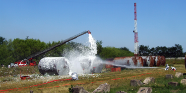
- Aviation: Airports with legacy use of PFAS-containing aqueous film-forming foam (AFFF) for fire training and emergency response.
- Defence: Former and active military bases with AFFF history.
- Fire services: Fire training centres, including the Fire Service College and network training facilities across England.
- Industrial processing: Electroplating, textile treatment, paper and pulp manufacturing, semiconductor production, chemical processing.
- Waste and water: Sites receiving or treating PFAS-contaminated wastewater, and land where PFAS-contaminated biosolids have been spread.
PFAS plumes in groundwater migrate, sometimes for kilometres, from their original source. A site may appear on the list not because PFAS were used there, but because a plume from an adjacent or upstream site has migrated beneath it. Understanding your site's relationship to the wider contamination picture, including what is happening in the surrounding catchment, is as important as understanding what happened on the site itself.
What happens once the list is published?
Publication does not automatically trigger enforcement, but it changes the context in which everything else happens.
Local authorities receiving new Part 2A guidance on PFAS (another commitment in the February 2026 PFAS Plan) will use the map to prioritise their enforcement workplans. Regulators will have visibility of sites that were previously unknown to them. Insurers reviewing environmental liability policies at renewal will be working from the same public dataset. And any transaction involving a listed property will require the buyer's solicitors to address the PFAS position with specificity.

The operators who will manage this best are those who are not surprised by the map. They have already assessed their site's PFAS position, understand what the data shows and where action is needed, and have a documented programme in place. That documented programme is not just a technical product, it is the evidence that transforms an open-ended liability into a bounded, manageable one.
What should you do now?
A critical first step is to request a PFAS exposure assessment before the list is published. A phase 1 desk-based assessment, drawing on site history, available monitoring data and regulatory intelligence can establish your likely position relative to the Environment Agency dataset in a matter of weeks. It is the foundation for every decision that follows, whether that is engaging proactively with your regulator, briefing your board or lender, structuring a transaction, or commissioning targeted site investigation.
More from our Knowledge Hub
 Insights
Is your site on the Environment Agency's upcoming map of high-risk PFAS sites?
 Insights
Building water resilience: How UK businesses can respond to drought risk
 News
NewsAdler & Allan acquire environmental remediation specialists Vertase
 News
NewsTwo Adler & Allan Group colleagues shortlisted at the 2026 British Forces in Business Awards
Environmental compliance today, creating a sustainable tomorrow
Helping you reduce risk to the environment and your operation by managing assets compliantly while achieving commercial, ESG, and net-zero goals.
Contact our experts